Access: Mt. Royal TH or the bike path in Frisco
Start: 0900, 5/2/2014
Total Distance ~6 mi R/T
Duration: 4 to 5 hours
Vertical: ~2000'
Aspect: NE
Weather: 30F-45F/clear, 10-20 mph winds above TL
Conditions: Wind compacted powder, corn
Peak 1 is the northernmost peak in the Tenmile Range rising prominently to the south of I-70 with Frisco in its shadow - especially in the winter when the sun sets at 1 PM over the western edge of town. The snowy summit stares at me every morning from my front porch so I've been itching to drop the Prom Dress for awhile. Save it for stable conditions with ~45° slopes crossing over cliffs and funneling into a 35° bowl.
The Approach:
There are really two choices. There's the obvious route from the Mt Royal TH that climbs past J-chute over Mt. Victoria with class 3 scrambling on the NE ridge to the summit. The summit often has a cornice that must be navigated to reach the east ridge and the entrance to Prom Dress. The traverse from the summit to the east ridge lies above 200' cliffs.
The other option is to skin from the bike path directly to the east ridge. The bike path option requires careful route finding as the summit is obscured by thick trees most of the way and there are several sub-ridges that can leave you removed from your destination.
Once you reach TL, gain the east ridge and proceed to the entrance on the looker's right of the ridge.
Tenmile Peak to the left
There are several line options along the ridge. Prom Dress is the upper most, roughly 3/4 of the way to the summit.
The Line:
Prom Dress Couloir has a 20' wide entrance. There is a vertical cliff band in front of a cornice of variable size with the entry of the line descending between the cornice and the cliff band.
Skier's right of the cornice is a second cliff band. The couloir extends for a couple hundred yards between the two cliff bands.
Dillon Lake in the distance
The entrance to the couloir is around 40° and tops out around 45° in the middle. The bottom funnels into the 35° NE bowl of Peak 1.
From the middle of the NE bowl looking up on Prom Dress
The exit is through the trees at the base of the bowl back to Frisco. Route finding is key.
Location: Clinton Lake in Lawrence, KS
Date Run: 4/19/2014, 0800 start
Place: 1 out of 100
Duration: 3:43:25
Average Pace: 8:30
Elevation: ~1000'
Weather: 50-72F
Race Website: http://www.psychowyco.com/id1.html
By mid-April it's mud season in the mountains so I decided it was a good time to get away and continue my slow pursuit of 50 marathons in 50 states. Since moving to Summit County, CO road running has all but completely lost its appeal. For that reason I was stoked to find this trail marathon in Lawrence, KS.
I've done a handful of trail races in the last several years, and the Free State now ranks among the top. It was somewhat of a last moment decision to commit. I attempted to register online before the deadline but the website was not cooperating. Luckily, the race director Ben had provided his personal number on the race page and assured me I could register in person at packet pickup. He was even kind enough to honor the lower online registration price. Perks of a smaller sized event.
Clinton Lake Trail Network
The Race
The distances offered were a 100k, 40 miler, marathon and a half, all of which were run along trails on the north shore of Clinton Lake. In order to spread the runners out, the ultras started at 0700 while the marathon and half started at 0800. The race started abruptly. Ben essentially said, "We have a great course, it's well marked, marathoners split from the half marathoners early on, rejoin them, and then split off again... sound good? Alright... GO!"
Listening intently to Ben the race director
The first split was after the first mile. ... Aaaaand I completely missed it because I was following closely behind a runner of the half. Fortunately another marathoner I had talked to before the race corrected my error by shouting after me after I'd only proceeded 200' in the wrong direction. There was a race volunteer standing at the split but he wasn't really paying attention. No harm but it could have easily ruined my day had it not been for the other marathoner.
The correct route continued along a cross country ski trail for about a mile before suddenly cutting left directly into the woods off trail. The deviation into the woods was well marked by flagging although I'm sure a few runners thought, 'can this be right?' The race director called this character builder "exfoliation". No joke. I was repeatedly clawed by branches and bushes. It was actually kind of invigorating. After briefly bushwhacking, the route led to a single track trail that quickly crossed a stream. This trail looped around rejoining the original split at about mile 3 and continuing along with the half marathon route.
Typical trail segment with flagging. (Image credit: http://runmoretalkless.blogspot.com)
At this point I was surprised to pass half a dozen (slower) marathoners. Apparently they had somehow gone off route around the bushwhacking bit and shortened it. This really irritated me - having missed the split and then passed marathoners that had clearly cut some corners - so I took off a bit faster than was prudent. I started passing half marathoners asking them if any other marathoners had passed. Before long I realized I was alone in the front so I tried to settle in to a comfortable pace. And the scenery made that easy. There were views of the lake through blooming redbuds as the sun was rising.
Running through a woodchuck nest
The route was moderately rocky with short rolling hills having moderate pitch in general. This was a welcome reprieve from the long steep sustained climbs I'd become used to in the mountains. One section -Red Trail- along the waterfront was more technical with lilypad-like rock hopping. It wasn't made any easier by having to pass half marathoners along this portion but it was enjoyable having to pay close attention to footwork.
The second and final split from the half marathoners at the end of Red Trail about 13 miles into the race was well marked with an aid station. The turnoff provided additional mileage for the marathon and ultra runners. Along this stretch I passed a few ultra runners but by and large the trail opened up with the absence of half marathoners. This segment of the trail looped around to the aid station at the split before continuing on for the final 3 miles to the finish.
Ratings
Race Organization (5=phenomenal, 1=atrocious): 3/5
The start was sudden. Some of the course markings in the beginning were questionable. But for the most part, being an area with a lot of intersecting and interweaving trails, it was remarkably well marked to avoid confusion. There were no mile markers until the very end, making it simultaneously pleasant and painful not knowing where I stood. The aid stations alternated between manned and unmanned. The manned aid stations were fully stocked with HEED, water, gels, candy, fruit, etc. I really liked that runners were required to carry their own hydration containers minimizing waste from once used small cups.
Course Difficulty (5=Pikes Peak Ascent, 1=a flat dirt road): 3/5
The uphill portions were brief and moderately steep. There were a few technical sections, particularly along the Red Trail segment. And the bushwhacking completely off trail was new to me. It was a lot more difficult than I expected but nothing like I've experienced in Colorado.
Course Scenery (5=engagement proposal backdrop, 1=concrete walls): 4/5
A picturesque lake and blooming trees within a clean forested area. The only drawback was the prevalence of close proximity parallel trails interweaving making them feel like they were nearly on top of one another at times.
Schwag (5=a tech T, embroidered towel & warmup pants, 1=a cotton shirt): 4/5
Got a tech tee and... (((drum roll)))... a beer mug. The medal was burly and unique to the marathon distance.
Overall: 4/5
Like I mentioned earlier, one of my favorite trail races despite the early hiccups.
Access: Ryan Gulch TH above Wildernest in Silverthorne
Start: 0800, 4/11/2014
Total Distance ~5 mi R/T
Duration: 4 to 5 hours
Vertical: ~2500'
Aspect: North
Weather: 30F-45F/clear, 10-20 mph winds above TL
Conditions: from high to low - hard pow, soft pow, corn, slush
Silver Couloir is one of the lines in 50 Classic Ski Descents of North America By Chris Davenport et al. Little Elvis Couloir is the line skiers right of Silver. And Elvis's Crotch is the rarely ridden, narrow deep cut couloir that bridges the rocky ridge between the top of Little Elvis and the bottom of Silver. It is best to ski it in soft stable spring conditions, as an avalanche or fall on this line would be high consequence.
The Approach:
From Ryan Gulch TH, proceed to the first marked trail intersection and turn left up the Buffalo Cabin trail. Continue through the trees to TL, gaining the ridge between the glacial cirque in Buffalo and the northern summit.
Glacial Cirque with Tenmile Range in the background
The top of Little Elvis is 100 to 200 yd before the first/southern access to Silver. Upon entry to Little Elvis, the entrance to Elvis's Crotch is guarded by a jagged rock pinnacle skier's left ~100' down.
Rock Pinnacle at top of Elvis's Crotch
Elvis's Crotch entrance is 45º sustained into a narrow choke that approaches 50º.
Choke at the top of the photo
The rest of the line is 40-45º with another narrow choke before the entrance to the bottom of wide open Silver. The chokes vary in width considerably with the snowpack. On this day, both the top and bottom chokes were little more than 2 yds across.
Approaching bottom choke
Beneath bottom choke
Looking down on Silver proper
Bottom 1/3 of Silver proper
The exit of Silver is skier's right into the trees along an aqueduct at the base of Silver above the Gore Range Trail. Exiting Silver can be a pleasant skin along an established skin track or a grueling bootpack over deadfall with ample route finding. After only a couple hundred feet along the aqueduct is the right turnoff onto the moderately steep uphill Buffalo-Willow Connect. It is not uncommon to miss the right turn and continue along the Gore Range Trail adding unnecessary miles to your trip. The Buffalo-Willow Connect will lead directly back to the Ryan Gulch TH.
Access: Gold Hill TH on the west side of HW 9 between Frisco and Breckenridge
Start: 1230, 8/24/2013
Total Distance: 9.58 mi
Duration: 1:23:30
Avg. Pace: 8:43
Lowest/Highest Elevation: 9,047'/10,331'
Weather: 65F/Partly Cloudy
The Route:
I run this from Farmers Korner, but ideally you would park at the Gold Hill Trailhead on the west side of HW 9.
From the parking lot, the route gradually climbs along a beetle kill
deforested plateau, winding to a flat, still forested trail junction at a
mile from the TH. Take a left to stay on the GHT, and start climbing again along single track.
Stay left
The top of the hill is reached after another mile. Descend along single track, past a trail crossing.
Continue straight
The GHT terminates at the Peaks Trail.
Turn right
Make a right onto the Peaks Trail and continue on a fast downhill for around 2 mi.
Emerging from the Peaks Trailhead, make a right onto the dirt road.
Turn right
Before the dirt road turns left, make a right onto a single track that parallels the paved rec path. If you cross the rec path, you've gone too far on the dirt road.
Turn right, staying left at the immediate fork
Follow the single track for about a mile, past the hospital.
At the split near the rec path, turn right to remain on the single track.
Continue right
There is a short, steep climb that levels out and leads past wetlands on the right. Beyond the wetlands, there is another split*. Stay left proceeding down a short hill to the rec path.
Continue left
Turn right on the rec path to return to the Gold Hill Trailhead in 2 mi.
*Alternatively, you could make the right onto the logging road to stay on dirt trails leading back to the Gold Hill Trailhead as discussed in my previous post about Ophir Mtn.
Overall Impression:
Standard to Summit County, once beyond the deforested beetle kill, this becomes a shady tree run with intermittent views of the Tenmile Range. The climb is strenuous but not demoralizing. The long downhill from the top of Gold Hill to the end of the Peaks Trail is fast and technical. But try to keep your eyes up. I've run into moose right in the middle of the trail on two separate occasions.
In autumn, the aspens along Peaks Trail reveal themselves.
It would be nice if there was no paved section at the end, though it's flat and manageable for a cool down.
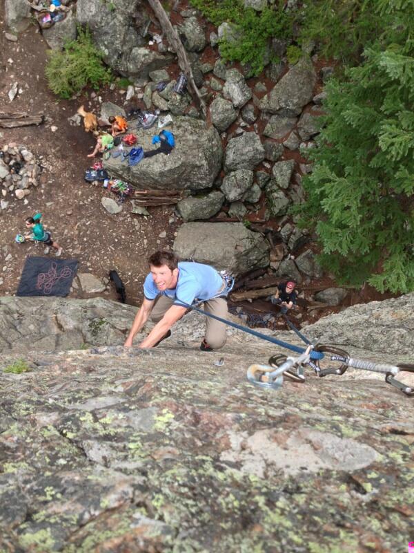
Access: Near Keystone. Unmarked parking lot on the north (left) side of Montezuma Rd 1.3 mi from US 6. Follow the trail and the cairns onward and upward from the parking lot. There is a left fork in the trail that is easy to miss. If missed, the trail leads to another, smaller bolted area called Hummingbird. Simply double back.
Difficulty: 5.6 to 5.10, slab climbs
The north side of Haus Rock offers 15 bolted sport routes. There is also a walk around for setting up top rope for some of the routes without leading. Mountain Project offers detailed descriptions of each route. Arguably the best rock to be found in Summit County, the area is often crowded on summer weekends. The friendly folks of Summit County frequently share ropes enabling several different routes to be climbed consecutively on top rope. Just be aware of the varying degrees of experience, etiquette and safety amongst the climbers found here.
Access: Summit County High School
Start: 15:58, 8/20/2013
Total Distance: 4.11 mi
Duration: 0:36:11
Avg. Pace: 8:49
Lowest/Highest Elevation: 9064'/9977'
Weather: 65F, overcast
The Route:
There is an entire network of single track, dirt roads, and game trails in the hills behind Summit High extending north to south between Iron Springs and the Colorado Trail at Gold Hill and bordered to the west by the Peaks Trail. This particular route starts on the rec bike path adjacent the high school. On the northwest side of the school, a narrow single track splits off left from the bike path in a spot where the bike path intersects with a perpendicular bike path leading to HW 9.
The trail climbs 300' in under a quarter of a mile to an old dirt logging road. Take a left on the logging road and continue climbing for about 150 yds. Near the top of the logging road, there is a steep trail that splits off to the right. If you start running downhill on the log road, you've gone too far. The steep narrow trail ascends 600' south through thick trees paralleling the rec path below. In a few clearings, there is a good view of Summit High and Farmers Korner below. The trail levels out at around 10,000' near Ophir Mountain's peak. Continue on to the T in the trail. Taking a left, the trail quickly wraps around to another split. Staying left, the single track descends about a mile where it turns into a double track.
Follow the double track until the double track makes a hard right. There you can hop off the double track and continue straight on a single track that leads to the Farmers Korner houses on the hill. The single track cuts left behind the hill houses and you can turn off right anywhere along the single track to hop on the paved road below that leads back to the paved rec path. Alternatively, you can remain on the double track. This leads you further south to a system of roads and trails in the Gold Hill area near the Colorado Trail.
Overall Impression:
The trails around Ophir Mountain do not see much traffic. They're a viable alternative to the overcrowded Peaks Trail on the opposite side of Ophir. In a county that has a lot of disappearing forests, the trails around Ophir are still thickly wooded. It is easy to get lost if you are unfamiliar with the trails, but if you have a grasp of the area - there are more variations than the Oregon Ducks football team's uniforms.


.jpeg)